Web Tools · InSAR Ground Motion Viewer

InSAR Ground Motion Viewer — Screen Satellite Ground-Movement Data On A Map.

Load an InSAR point dataset — EGMS tiles, ASF HyP3 displacement GeoTIFFs, TRE Altamira shapefiles, or any CSV/GeoJSON in the interchange format — and get velocity mapping, per-point time series with trend fitting and standard errors, section profiles along an alignment, threshold screening with clustering, per-asset statistics and a printable report. Hundreds of thousands of points stay interactive. Download free with a KeoGeo sign-in.

v2.5.0 (Beta) · download and run locally · A$50 one-off, lifetime re-downloads and updates
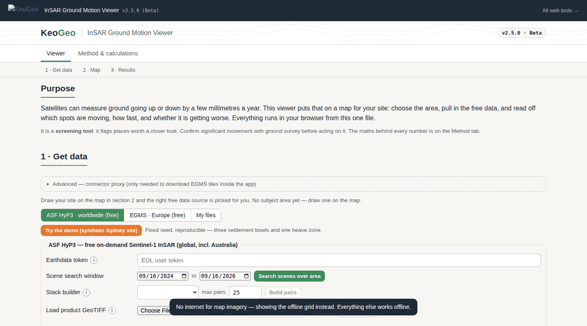
InSAR Ground Motion Viewer web app — Map, layer and colour controls on one screen; time series, section profiles, screening tables and the verification table sit in their own tabs.

Map, layer and colour controls on one screen; time series, section profiles, screening tables and the verification table sit in their own tabs.

What It Does

From Product Download To Screening Report, In One File.

The viewer covers the whole InSAR screening chain, from working out which product suits the subject area to the numbers that go in the report:

  • Acquisition — calculates the EGMS tiles for an area and fetches them, or searches ASF for Sentinel-1 scenes and submits HyP3 jobs with a stack builder (path/direction pairing, 6–48 day gaps, batch submit).
  • Readers — EGMS L2a/L2b/L3 CSV, HyP3 Float32 displacement GeoTIFF (uncompressed, LZW or deflate; strips or tiles; UTM or WGS84), TRE Altamira shapefiles, and the pid, latitude, longitude, mean_velocity, D<YYYYMMDD>… interchange CSV that a MintPy run exports directly.
  • Trend analysis — least-squares velocity with slope standard error, Theil–Sen robust option, and an annual-harmonic fit that separates seasonal amplitude from the secular trend; reference point or area subtraction.
  • Screening — threshold exceedances grouped into clusters on a metre grid, with a table, map circles and a report section; displacement-at-epoch colour mode with a time slider.
  • Assets and sections — GeoJSON structures, alignments or pipelines get per-asset statistics within a search radius; section profiles by chainage along a drawn or imported alignment.
  • Coordinate handling — LAEA EPSG:3035 (EGMS), Transverse Mercator / UTM and WGS84 conversions verified against IOGP test points.
  • Performance — canvas point layer with screen-space decimation that preserves worst-case points, pooled series storage and worker-thread unzipping.
  • Verification table — 19 in-app checks tied to hand-worked normal equations, IOGP projection test points, synthetic harmonic series and known clustering cases, re-run on every load.

A$50 one-off · tied to your KeoGeo account · re-download any time, new versions included · 14-day refund if it doesn't work for you · KeoGeo Pro subscribers can spend their one-time A$50 credit on this tool

Example Outputs

What You Get Out Of It.

Velocity Map

Points coloured by mean velocity or displacement at a chosen epoch, with legend, basemap and decimation that keeps the worst-case points visible.

Time Series And Trend

Per-point displacement history with the fitted trend, its standard error, seasonal component and reference correction.

Screening And Asset Tables

Exceedance clusters and per-asset statistics with CSV export.

PDF Report

Map, series, sections, screening and asset sections assembled into a printable report.

Method & References

What The Numbers Are Based On.

Every calculation in InSAR Ground Motion Viewer is tied to a published source, and the in-app Sources & References section repeats this list next to the calculations themselves:

  • European Ground Motion Service (EGMS) product specification — L2a, L2b and L3 products, LAEA EPSG:3035 tiling.
  • ASF HyP3 — Sentinel-1 InSAR displacement products (Float32 GeoTIFF) and the HyP3 jobs API; MintPy time-series output.
  • Ordinary least squares with slope standard error; Theil–Sen (1968) robust slope; harmonic regression for seasonal signals.
  • IOGP Geomatics Guidance Note 7-2 — coordinate conversion test points (LAEA, Transverse Mercator / OSGB worked example).
Limitations

Where It Stops, And What You Still Have To Check.

  • A screening tool, not a design tool. Absolute velocities inherit the product's own reference unless one is set.
  • The GeoTIFF reader targets HyP3-style products; predictor-3 compression and non-UTM CRSs are refused rather than approximated. GeoPackage and Esri geodatabase inputs are not yet supported.
  • L2b access needs lookup data built from the portal's bulk manifests — the mechanism ships, the data does not. EGMS fetching from within the app needs the optional KeoGeo proxy worker.
  • Because it talks to ASF, HyP3 and EGMS directly, the viewer runs as a downloaded file rather than inside the keogeo.io page.

All KeoGeo tools are provided for preliminary assessment and educational purposes. Results must be verified by a suitably qualified engineer before use in design or construction; the full disclaimer is inside the app and in our terms.